Caroline Birchall, Founder & CEO Bee Collective
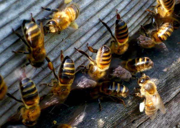
As most people are well aware, bees and other pollinating insects are in trouble. Honeybees, bumble bees, solitary bees, hoverflies, butterflies and moths all provide valuable pollination services for the flowers, fruits and vegetables that we grow in our parks, gardens and allotments. They are also important for ensuring that natural and semi-natural habitats are healthy and resilient. But there has been a significant decline in the abundance and diversity of pollinators over the last 50 years or so; due to reduced quantity and quality of habitat, increased use of pesticides, emergent pests and diseases, and the effects of climate change.
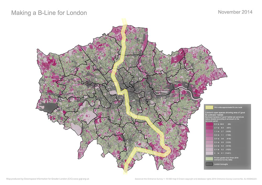
Making a B-Line for London is a partnership initiative to increase the diversity and abundance of pollinators in London.
The project will test a landscape scale, partnership approach to pollinator conservation in an urban context. It will demonstrate simple changes we can make to the way we manage London’s green spaces and provide tools and advice to increase the amount of habitat for pollinators.
The first phase, funded by the CB Dennis Trust, used GiGL datasets to determine where the best existing and potential habitat for pollinators exists in London. Based on this model, the project identified three levels of focus:
- A London ‘B-Line’ from Enfield to Croydon to target public and stakeholder engagement.
- One or more project areas along the B-Line where we will test and showcase what can be achieved for pollinating insects, their habitats and people, through changes in land management.
- An on-line toolkit for London boroughs, greenspace managers and community groups to identify and create B-Lines in their local areas; supporting the development of an interconnected network of B-Lines across the capital.
The project will be delivered over five years so that changes in pollinator diversity and abundance along the B-Line can be monitored effectively. Currently, we lack this specific data, so it will be important to establish a baseline and monitor changes in response to the project interventions.
By developing an approach based on evidence and by providing tools for people to get involved we hope to increase participation in improving London’s landscape for pollinators and people alike.
The partnership comprises Bee Collective, Buglife, Forestry Commission, Greater London Authority, GiGL, London Wildlife Trust, Natural England, RSPB and the University of Sussex. This partnership will expand during delivery to include green space managers, landowners, community groups, households, schools, businesses, allotment associations, beekeeping associations and the public.
Caroline Birchall is the founder and CEO of the Bee Collective. It was her MSc studies in Biological Crop Protection that got her hooked on plant/insect interactions, not just pollination but herbivory and plant defences as well. She has worked in research, including a three year project on honey bee pathology, developing biological control for the varroa mite, but it was only whilst working for Natural England that she got her own bee hive to manage at their London head office.
What did GiGL do?
Chloë Smith, GiGL Data Officer
The initial concept for Making a B-Line For London was to identify and join up areas of good quality pollinator habitat. This required both landscape and local information. The first task was to define best quality habitat. Dr. Karin Alton, from Sussex University’s Laboratory of Apiculture and Social Insects, lead the appraisal of GiGL’s habitat data categories to assess which of these would be most and least favourable to pollinators.
We knew that some urban land uses favour pollinators so, using the same approach as Karin, Lynne Osgathorpe from RSPB lead an assessment of the pollinator potential of each of the principal land use types listed in the GiGL open space and Ordnance Survey private garden land datasets.
The resulting information gave GiGL the building blocks to make an informative Geographical Information System model. The basic unit for consideration in the GIS model was the habitat survey parcel. Sometimes these comprise a whole site, sometimes they are parts of a site with a similar composition. For example, St. James’s Park is one open space, but includes four distinct habitat survey parcels.
To get a measure of how good each parcel might be for pollinators, we calculated the total area of the best pollinator habitats it contained. For example, if a parcel comprised 0.3 hectares amenity grassland, 0.2 hectares scrub, 0.2 hectares bare artificial and 0.7 hectares orchard, the total area of promising pollinator habitat would be 0.9 hectares (orchard and scrub). The B-Lines concept suggests that areas of two hectares or more of quality habitat are desirable, so we also added a flag to highlight any parcel that included two hectares or more of the best scoring habitat. If a parcel was an allotment or a community garden it would also be flagged as having the best potential for pollinators in terms of land use.
As a reference, GiGL also counted the number of pollinator species that had been recorded within 500m of each parcel and listed this along with its other details.
We developed two ways of visualising the habitat and land use calculations. The first was to apply a threshold and visually pick out the top scoring sites on a map; parcels with at least two hectares of potential pollinator habitat and/or a high land use score. Secondly, to allow for relative assessment of pollinator friendly habitat, we shaded each parcel according to its total area of good pollinator habitat.
In a separate exercise, GiGL considered the interaction between habitats. Firstly, we highlighted where land with good potential for pollinators is also surrounded by a relatively large area of private garden; itself considered good pollinator habitat. Finally, we also wanted to visualise how the top scoring parcels of land interacted with each other. So, GiGL indicated in the mapping where land with good potential for pollinators is also close to other land parcels of similar quality.
The mapping and modelling of GiGL datasets has provided a basis for discussion and analysis, enabling the project to assess London’s landscape at a regional, borough and local level. We found good quality land parcels all over London in a complex distribution, which presented many possibilities for locating the B-Line. The underlying data is now helping the project to focus on the local detail of chosen areas within the B-Line. Eventually, we want the customised datasets that we have been using to be available to other practitioners in London, as a basis for their own development of local B-Line projects.
Hello,
I’m wondering if there is an update on this project? A google search just takes me to this newsletter article. I am churchwarden at St James’s Church Piccadilly which is right on the B-Line, and we work hard at promoting biodiversity in our green space.
I’d be grateful for any information,
many thanks, Deborah Colvin
Hi Deborah, many thanks for your interest in the B-Line. I’ve passed your email address onto the project’s coordinator who should be in touch soon to discuss how you can get involved.
Hi, I help to run Friends of Meath Gardens in Bethnal Green (E2 0SN). We have a largish Park of over 4 hectares and we are actively working with local residents to create wildlife friendly habitat for bees and butterflies. We are also thinking about acquiring some bee hives for Meath Gardens. Can we be a part of the B-line project? Please email me so I can find out how we can get involved. Our residents and volunteers will love this!!