Sutton has some incredible gardens. The southern half of the borough is particularly impressive, with gardens a hundred metres-deep. Back to back, neighbour to neighbour, these gardens can stretch a thousand metres; Banstead Road South, Pine Walk and Chiltern Road stand out. Big gardens are not unusual for outer London Boroughs; Harrow, Hillingdon, Bromley and Brent are similar. But, being new to Sutton, I couldn’t help but wonder how significant these garden corridors must be for wildlife in urban areas.
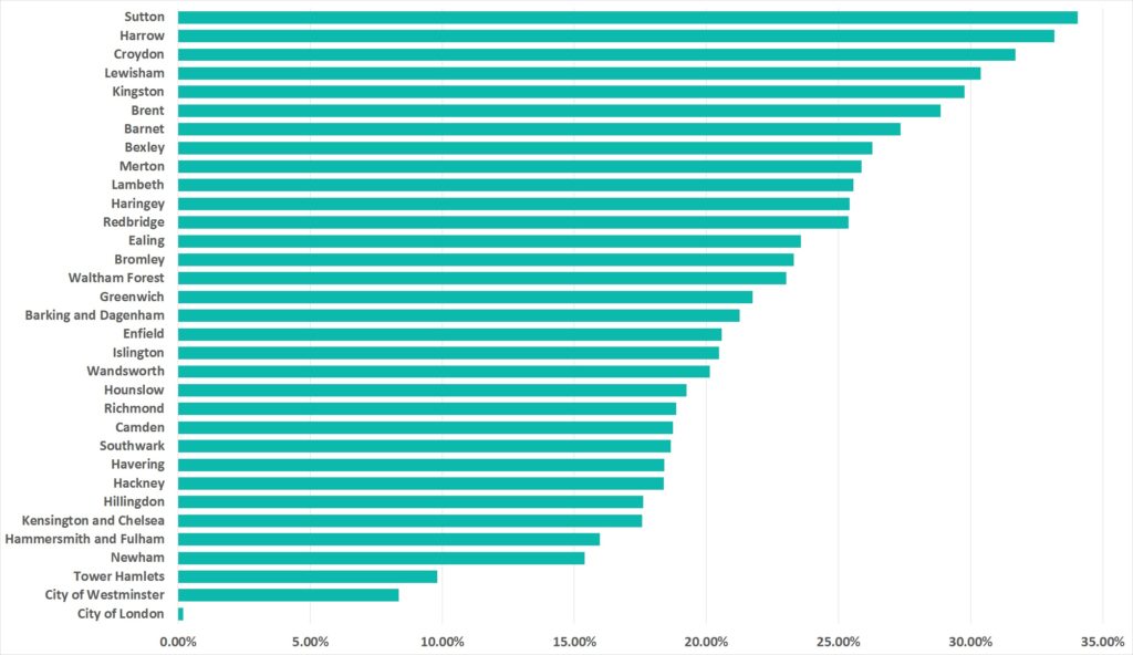
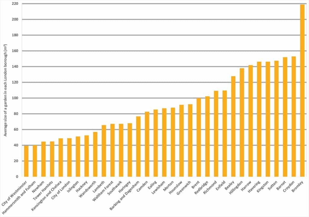
One of the benefits of being an SLA partner with GiGL, London’s local environmental record centre, is that I was able to explore my intrigue and ask about the data available. To my surprise, I found out Sutton has the highest percentage of garden land of all London Boroughs at 33% (Figure 1). The average size of its gardens at 148m2 puts Sutton at 4th place (out of 33 boroughs) (Figure 2). That sounds impressive, and I wondered how many ponds, swimming pools, trees, and trampolines that could amount to!? Joking aside, 33% is a third of the borough, greater than all of Sutton’s Sites of Importance for Nature Conservation (SINCs) put together.
These figures are derived from Ordnance Survey material with permission of Ordnance Survey on behalf of the controller of Her Majesty’s Stationery Office © Crown Copyright. London Borough of Sutton 100008655X (2022)
Looking at the borough on Google Earth, back to back gardens provide much of the greenery across the borough. Small and fine-grained in the north, getting larger, longer and more distinctive as you move southwards. The borough’s 54 SINCs are in no doubt supported by this patchwork of garden corridors, connecting and buffering them from busy and polluted roads. For example, the River Wandle between Beddington Park and Wilderness Island is bordered entirely by back-garden land, providing a green corridor for species using the river.
Whilst the borough’s SINCs and open spaces have a known value for wildlife, gardens in contrast are an enigma, we have little idea of their value or how they are managed. The lawns may be regularly mown, but could support rare chalkland species if allowed to flower. The mature oak trees and their surrounding soils could be relic patches of ancient woodland, portioned off and forgotten about within private gardens. The predominant building stock of Victorian terraces are well known to provide roosts for bats and nests for birds and all of this potential richness is in the hands of homeowners who don’t know, don’t understand or don’t have time to care.
Most UK gardens contain in the region of 70% non-native species and it has been demonstrated that an ‘average’ UK garden can contain large numbers of species. The BUGS 1 & 2 projects suggest that mature trees and vegetation in urban gardens ‘could be the best way of enhancing abundance in the widest possible range of taxa’.
The borough’s Biodiversity Team organises regular walks and talks around Sutton to engage residents with the wildlife on their doorstep. In 2013, the council received funding specifically to encourage biodiversity in gardens, organising events, publishing educational material, engaging schools and collecting and sharing over 4000 species records with GiGL over a two year period. This year, we are working with local plant nurseries to aim to grow native chalk grassland species as part of the Mayor’s funded, re-wild London project “Link the SINCs”.
Piecemeal loss of garden land will continue to happen, given insensitive development, permitted development rights and the desires of homeowners. Gardens are where Sutton residents have a very real power to protect, conserve and create life, if they want to. Effective local decisions will be a contributory factor in halting the decline of garden land in the borough, recognising the importance of garden space and ensuring planning decisions don’t undermine this resource. Sutton’s Local Plan has a number of policies that aim to protect gardens for the different benefits they provide. Policy 13 recognises the value of gardens and planning permission will not be granted on areas of back garden land ‘either individually or as part of a larger street block’ that are ‘considered to be of local ecological value by the council’. Policy 30 recognises gardens, trees and hedges as elements that can contribute to the special character and appearance of Conservation Areas and Policy 33 notes these as contributing to urban cooling and flood-risk management. The main policy for biodiversity (Policy 26) does not explicitly mention back gardens but instead the Council operates a No Net Loss approach to biodiversity, using a metric to calculate baseline and post development values and request enhancements through new development wherever possible. Any vegetation loss of greater than 100m2, including in back gardens, triggers the requirement to undertake a Biodiversity Net Gain Assessment.
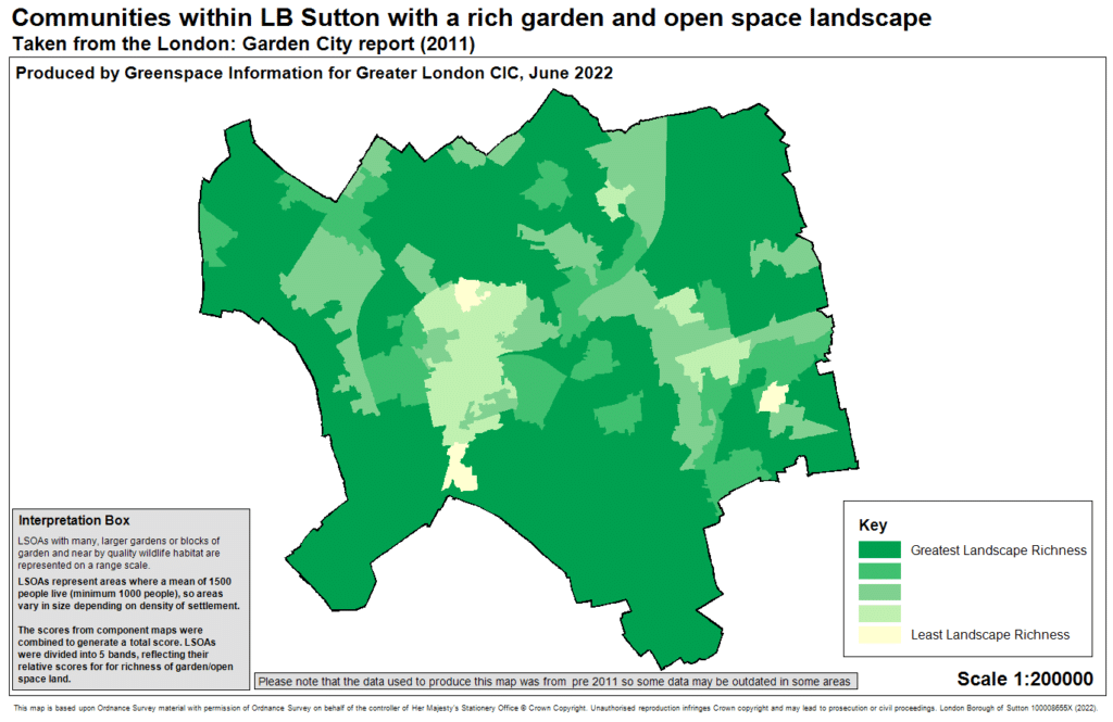
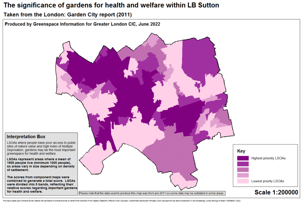
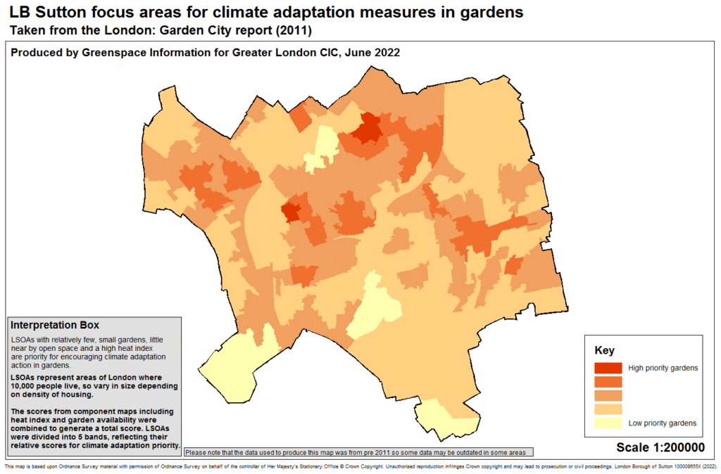
A while back, GiGL published a study called London Garden City: From green to grey. The aim of the report was to understand the scale and character of the garden resource and its value to the wider urban population. The report is excellent and well worth a read, but what I found most interesting was a series of garden “character” maps that were created using the Lower Super Output Areas (LSOAs). This method uses population size to divide London into a basic unit which can then be compared regarding their garden resource. I could see these maps being useful to planners and designers who need to ensure their recommendations are locally relevant. GiGL updated three of the four maps to focus on Sutton, so the results could be explored in greater detail, although the data may require greater interpretation, updating and revising, given the scale and timescale of the original map.
Map 1 shows communities with a rich garden and open space landscape. Map 2 shows where the role of gardens for health and welfare may be most significant. Map 3 shows where people could focus on greening up their garden for climate adaptation measures.
Sutton has pledged (as part of their Environment Strategy 2019-2025 and climate emergency response plan) to be London’s most sustainable borough. The borough will have “more green spaces, connected to each other, protecting and enhancing nature and biodiversity” ….” We will be able to withstand heat waves, droughts and flooding caused by climate change. Everyone will know and play their role in reducing their impact on the environment” Could these maps be the foundation for understanding how Sutton’s residents contribute to the borough’s Environment Strategy? The next two years are critical, so what are your next moves? Do let Sutton’s Biodiversity Team know!
Working as a gardener I recognised bee orchids growing in a lawn in Cheam and managed to help them survive.
They were joined by pyramidal orchids a few years later – both from seed blown in from nearby Surrey habitat?
Another garden in Sutton had ivy broomrape growing under an old hedge in a front garden – which could be lost to changes or development? Another colony of this(?) broomrape has just been found on the bank of the River Wandle, just yards from a new housing development. Other orchids have been found in a nature reserve in the area after many years . . .
It only takes a quick redevelopment or even a falling tree to eliminate something we don’t know exists . . . .
Fascinating and brilliant
Interesting article, and brilliant to see how Sutton have implemented policies to go some way to reduce the insensitive development. Also excellent that the maps you show are illustrating some of the really critical ecosystem services (supply and demand) across the borough as a way of demonstrating the wider benefits of nature.
Fascinating article
Redington Frognal Neighbourhood Forum would like to devise a method for assessing a garden’s value to wildlife, so that this could be recorded by GiGL. Hopefully, the garden’s wildlife value could then be taken into account when determining planning applications for garden building etc.
If anyone would have any thoughts on a possible scheme such as the US Certified Wildlife Habitat 35038, these would be greatly appreciated.
Hi Nancy – thank you for your suggestion. I love it! Perhaps something that National Park City or London Wildlife Trust could help with – but would need funding. Surrey Wildlife Trust had a scheme which they ran a few years ago. https://www.surreywildlifetrust.org/sites/default/files/2018-04/Surrey%20Wildlife%20Garden%20Award%20Check%20List.pdf – it was as much a check list as a project to do list but the more ticks a garden got the more “points” they were awarded. This could be a starting point. Species such as newts, frogs and reptiles would be really useful to know too – for GIGL and other third parties. Happy to discuss further – rosie.whicheloe@sutton.gov.uk