Access to reliable ecological data is essential for understanding, protecting and improving London’s natural spaces, for the benefit of both wildlife and people. Yet too often this information remains scattered or underused. This new article series explores how stronger partnerships and better data sharing can bridge those gaps. This is our second article in the series, following October’s piece by Iain Boulton, which highlighted the role of GiGL’s partner organisations, such as local councils, in helping the public and GiGL capture and make the most of these valuable data.
Ecological consultants perform a vital function advising developers on the potential impacts of a development project on biodiversity. They use existing data in desk studies, for example by utilising GiGL data search reports, and collect new data by doing on-site surveys and assessments. This enables them to provide their professional advice on how best to avoid, mitigate and, as a last resort, compensate potential impacts on species and habitats.
Various organisations alongside GiGL recommend the sharing of data from development so that best practice is upheld in the sector, giving integrity to the data we all work with and share. These data could include species, habitats and green infrastructure data, as well as biodiversity net gain baseline and delivery. However, as outlined on our data sharing from development webpage, we rarely receive environmental data from planning applications.
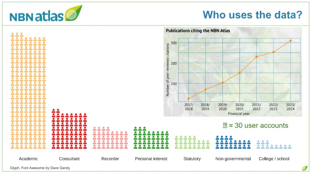
In 2024/25 there were 59,733 planning applications received by local authorities in London but GiGL’s statistics expose that only 1.7% of those were informed by a GiGL data search report (despite the Mayor of London’s 2016 research that concludes 18% should be). This means that it is likely that at least 1,000 planning applications had ecological surveys undertaken. Yet less than 0.5% of our species data could be attributed to planning applications, and even less of our habitat data have come via this route. The National Biodiversity Network Trust (NBN) also observes a similar pattern nationally with ecological consultants being the second group after academics to be using the NBN Atlas data the most, but with data sharing numbers very low (information shared during NBN Conference 2025).
“When data are shared, it can be re-used to enable informed decisions for future projects, inform local plans strategies and reporting, and enhance our understanding of an area”
In this article we want to highlight the importance of sharing data from planning applications and celebrate the ecological consultants who do consistently share data. We’ll hear from three smaller consultancies who have been regularly sharing data with GiGL at least over the last 5 years – Ecology and Habitat Management Ltd, Ecology Network, and Kingfisher Ecology Ltd – who share their perspectives on why they consider it an important part of their work.
The importance of sharing newly acquired species and habitat data lies with the value of their re-use. These data are usually used once for the particular planning application and then lost in reports within the planning portal. Whereas if they are shared, they can be re-used to enable informed decisions for future projects, inform local plans, strategies and reporting, and in combination with other data, enhance our understanding of an area. Sharing of these data also ensures that species experts are informed of new recorded locations and improves awareness and consideration of nature in London.

GiGL works closely with ecologists so that data are shared and we wish to have more mutually beneficial relationships with them. We appreciate the ecologists that already share data with us. The three consultancies featuring in this article comprise of small teams or only one person and are a great example of how smaller teams can prioritise sharing of data when its importance is recognised. Some share data primarily from planning applications and infrastructure works (Kingfisher Ecology Ltd) while others do so from a combination of planning applications and personal observations (Ecology Network). The Ecology and Habitat Management Ltd mainly performs surveys at Heathrow’s biodiversity sites and impact assessments prior to works around the airport. Though data are not collected for planning applications per se, they make sure that they share any records with GiGL. Whether part of official policies or engrained in their daily operations due to personal interest, these three companies make the time every year to share data.
The Ecology Network also includes a relevant clause in their contracts with developers. Kingfisher Ecology shared that they occasionally work on projects subject to BREEAM1 which requires submission of data to Local Environmental Records Centres (LERCs) like GiGL, when targeting particular Land Use and Ecology credits. The Heathrow team that oversees the conservation work on Heathrow’s biodiversity sites also requires data sharing with LERCs, the Ecology and Habitat Management Ltd team noted.
We also asked why they believe it’s important to share newly acquired data. Here’s what they told us in their own words:
Adam Cheeseman, Ecology and Habitat Management Ltd
One thing I have become acutely aware of when I do PEAs2 for small scale developments is that more often than not there is very little information sent back by the local record centre involved. Obviously, there are sensitive records that are either not divulged or are scant in their information, but other than this there can often be few records returned which, when I visit the site, seems rather incredible in most cases given the nature of their locations and can only be as a result of lack of survey effort or coverage backed up by very few records actually being sent in to the LERC. This has led to a discussion within our team that we should now look to making it within our remit to send in any species records we note when carrying out inspections to lead to a greater understanding of what species are out there.
Tiffany Lewins, Kingfisher Ecology Ltd
It’s essential that up to date biological information is provided for each site we work on. Up to date data informs us of the habitat types present and the likelihood of encountering particular species within those habitats before we even set foot on a site. The data provided enables us to design habitat enhancements to benefit the individual site and also ensure connectivity to the wider landscape and the species within them.
Dr Greg Carson, Ecology Network
Very simply, built development has the capacity to impact upon biodiversity. The greater our understanding of what may be present within one geographical area, the more capacity we have to tweak our development, to not only prevent biodiversity loss, but also be more effective in ensuring biodiversity gain.
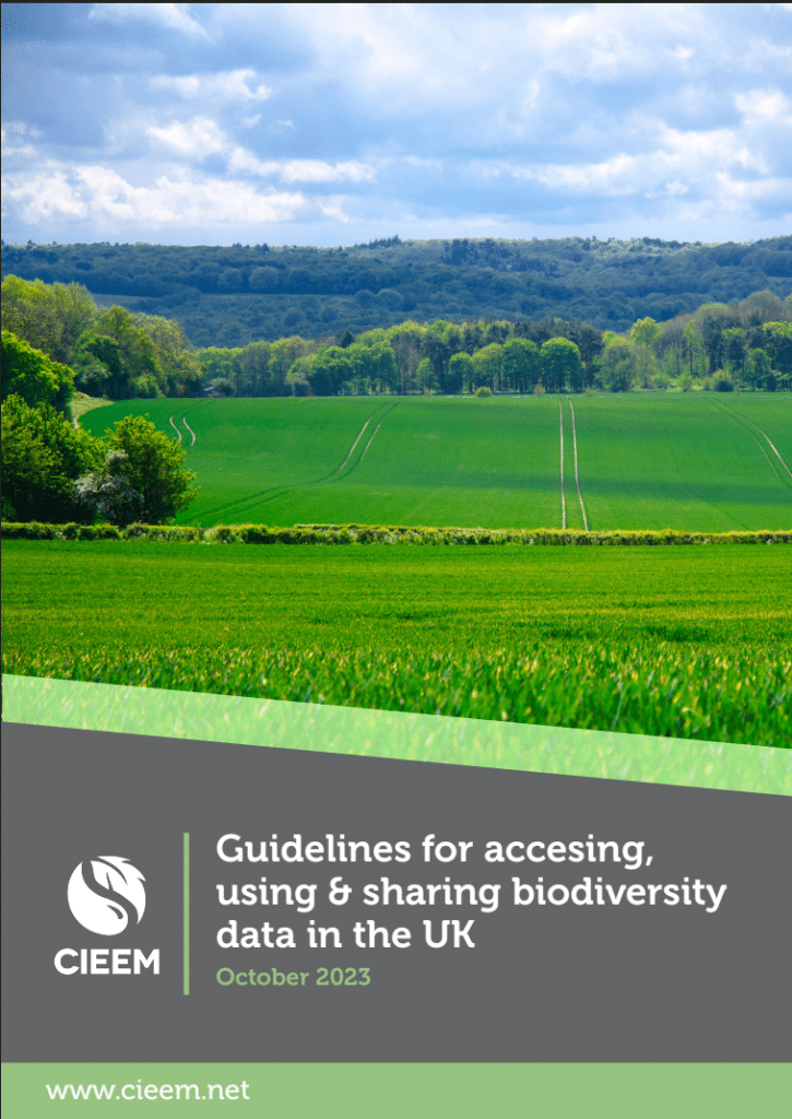
Dr Greg Carson also noted that members of the Chartered Institute of Ecology and Environmental Management (CIEEM), are required to abide by the Institute’s Code of Conduct, and highlighted Section 8 within CIEEM’s (2023) Guidelines for Accessing, Using and Sharing Biodiversity Data in the UK:
“Following the completion of surveys, all relevant biodiversity data obtained should be submitted to the relevant LERCs and other groups as appropriate, unless the client has expressly refused permission for this. A statement to this effect should be included in the consultants’ Terms and Conditions. Data can be submitted direct to the LERC.“
The challenges in not valuing data
Developers can miss the importance of sharing these newly acquired data with records centres like GiGL, and the absence of a clear requirement to share the data in the planning process means they don’t give permission or cover the time consultants need to share them. Moreover, consultants are usually overstretched and find it difficult to prioritise this on their own time. A project in 2016 between Build UK, GiGL, the Association of Local Environmental Records Centres (ALERC) and The Ecology Consultancy, found that there are other barriers in sharing data which most likely could be overcome with collaboration and developers’ contribution (for more information see further reading here). However, making it a national requirement would go a long way to addressing many of the issues and ensure that (as both the National Planning Policy Framework and London Plan note) decision-making is based on the best available information.
Bridging gaps for better data
As a social enterprise, GiGL’s purpose is to raise awareness of the importance of data sharing both nationally, as well as regionally and locally to develop processes that will make environmental data sharing common practice. Many local authorities have a section in their planning documents requiring developers to share natural environment data with us (whether that’s a validation checklist, supplementary planning documents or planning application requirements) but very few actually do. We would like to see this becoming a national requirement and ALERC has been working at a national level to raise awareness on this, and have gained support from a member of the House of Lords, Lord Lucas, who is a great advocate for evidence based decision making and champions the work of LERCs and the NBN.
In the meantime, we would welcome some advocacy for data sharing from our regional and local stakeholders who stand to benefit from our collective improved awareness of our natural environment in London.
If you’d like to send us your records, a recording spreadsheet can be found here: https://www.gigl.org.uk/submit-records/recording-spreadsheet/ or records can be emailed straight to submit@gigl.org.uk. If your organisation uses iRecord as a recording platform, we will also receive these records, but do consider creating an activity so we can easily attribute records to your organisation (see https://www.youtube.com/watch?v=kONsVbEK434). The essential information we need to accompany a species record is the ‘who, what, where, when’ – who is the recorder, what species is it, where was it spotted, and when. Further details are always helpful, especially images to help with verification. We have also produced a series of data standards guidance documents which can be found here.
- Building Research Establishment Environmental Assessment Method: a system for assessing and certifying the sustainability of the built environment, including buildings and infrastructure, ensuring that projects meet sustainability goals and continue to perform optimally over time ↩︎
- Preliminary Ecological Appraisals ↩︎