Matt Davies, GiGL Data Manager

A new online mapping interface that allows Londoners to find London’s parks open spaces and wildlife sites has emerged out of the demise of similar services, the rise of the All London Green Grid and increasing demand for web-based access to GiGL’s key datasets.
At GiGL, we are increasingly being asked to deliver key datasets without the need for GIS and other desktop mapping software. iGiGL is the answer. It builds on our existing on-line mapping services: What’s In My BackYard (WIMBY) and the Wildlink ’Databank’ tool.
iGiGL also provides an alternative to two of the GLA’s web-based portals, which are no longer available, for information on green and open spaces: Wildweb, which encouraged Londoners to make the most of wild places by exploring them online before getting out and experiencing them in the real world, and, Your London, which provided information about parks and open spaces. The GLA was happy to part-fund iGiGL as a viable alternative to these two services. They were also happy to support GiGL in using iGiGL to manage wildlife sites data that, along with our open space data, underpins projects including the All London Green Grid.
As active partners in the All London Green Grid, iGiGL appealed to the Environment Agency because an interactive online mapping tool would enable the wider ALGG partnership to view, review, and share this open-space information. For this reason the EA also agreed to part-fund the project.
Inclusion of the SINC information, previously held on WildWeb, on iGiGL gives members of the public more complete information about accessible wildlife sites. The functionality of iGiGL will be especially useful for schools, environmental groups, Londoners interested in the natural world, and visitors to the capital.
It should be noted that iGiGL is not designed to provide the definitive boundary, citation or status of SINCs. For this information, ecologists, planners and other professionals requiring specific and validated data should continue to use the Request Report section of the GiGL website, or become partners.

The key to the success of iGiGL is the development of a simple to use and intuitive interface. We have made good use of open source and free software which meant our resources could be spent on making it as user-friendly as possible.
exeGesIS were appointed to develop the interface and suggested using background mapping data from Ordnance Survey rather than Google or Microsoft as there are fewer licensing restrictions – and as the Ordnance Survey are currently in dispute with Google over displaying anything that has been traced from one of their maps. The interface was developed using open source code, which has the advantage of not being tied to any particular mapping. However, users don’t need to worry about such technicalities because the mapping interface is self-explanatory
Datasets currently available on iGiGL
| Open-spaces |
| Parks and formal gardens: London has an exceptional network of parks and gardens, from the Royal Parks and large Victorian parks through to smaller, more intimate, local neighbourhood parks and gardens. Formal gardens include the London squares common to central London, displaying high standards of horticulture and intricate landscaping. Commons and nature reserves offer less formal settings, and can provide brilliant wildlife-spotting opportunities. |
| Outdoor sports facilities: Whether you are looking for a playing field with designated playing pitches or a recreation ground for more informal games, many of London’s open spaces are dedicated to outdoor sports activities. Outdoor sports facilities shown on iGiGL include golf courses, bowling clubs, tennis clubs and other recreational spaces. |
| Other open-spaces: London is greener than you think, with hundreds of smaller green spaces ready to be enjoyed. Whether it is a local playground or allotments, grassed areas among housing estates or accessible agricultural land and city farms, there will be something for you nearby. |
| Publicly accessible wildlife sites |
| Site of Metropolitan Importance are those sites which contain the best examples of London’s habitats, sites which contain particularly rare species, rare assemblages of species or important populations of species, or sites which are of particular significance in otherwise heavily built-up areas of London. |
| Site of Borough Importance are sites which are important for wildlife borough-wide in the same way as the Metropolitan sites are important to the whole of London. While protection is important, management of borough sites usually allows and encourages their enjoyment by people and their use for education. |
| Site of Local Importance are sites of particular value to people in the immediate area (such as residents or schools). These sites may already be used for nature study or be run by management committees mainly comprised of local people. |
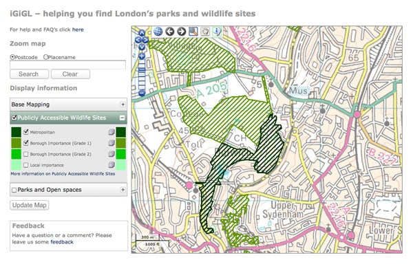
Using iGiGL is a very simple three-step process:
1. Zoom map to your area of interest, either via the gazetteer or by clicking and zooming on the map.
2. Turn on/off wildlife sites and parks using the concertina-style key and press ‘refresh map’ to update what’s displayed. You can even adjust the transparency of the layers so it displays just the way you want.
3. Click on sites on the map for a description of what’s there, opening times and such like. Basic information will appear in a bubble with links to a full fact-sheet.
This just the beginning for iGiGL. We’ve barely even launched and are already being asked by other GiGL partners if the functionality can be extended. The answer is an emphatic YES! Future developments could include:
- Allowing users, with appropriate log-in access, to edit/update certain datasets, in order to keep all project partners and steering groups up to date with the current status, new contact details and other important information.
- Allowing users to upload photos of their project/ site, which will facilitate monitoring project progress and maintenance of facilities, amongst other things
- Allowing users to download entire datasets, in GIS format.
If you have any further suggestions for how iGiGL could be improved to meet your needs, get in touch with Matt Davies matt.davies@gigl.org.uk.
