Claudia Watts, GiGL Royal Parks Officer
The Royal Parks cover approximately 5,000 acres, making an enormously important contribution to open space and wildlife habitats in the capital.
Such a wide area means that there is a lot of wildlife to be recorded. The Royal Parks’ data currently account for nearly 10% of the total GiGL database. We even have a dedicated GiGL Royal Parks Officer, funded by The Royal Parks, who works with The Royal Parks’ Head of Ecology and Ecology Officer and deals solely with the biological records generated in the parks. These data come from many sources in a range of different formats and form a valuable resource that informs parks management, research, event planning and conservation activities.
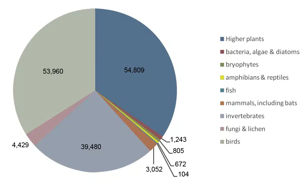
Royal Parks records as at May 2010. Breakdown by taxonomic group.
The most recorded taxonomic group is the flowering plants. Tree data from Arbortrack the GIS-based tree-management software used by the the parks’ arboricultural officers have been loaded into Recorder. So far, we have transferred 25,500 records, but this is only a fraction of the estimated total of 150,000 trees in the parks.
The other major source of plant records is from surveys commissioned to produce Phase 1 habitat and NVC (National Vegetation Community) maps of all the parks, including the Longford River. These are essential to ensure good management of, for example, the regionally important areas of acid grassland, a BAP priority habitat. The NVC surveys provide a baseline against which to monitor future changes.
Other recent surveys have been carried out to assess the invertebrate richness of veteran trees in Richmond Park using flight-interception vane traps. A similar survey is currently in progress at Bushy Park. These have helped to highlight the national significance of these parks for rare and scarce saproxylic (decaying-wood) species. The rich fungal community has also been surveyed in Richmond and Bushy Parks and Kensington Gardens, and moth-trapping has been carried out at St James’s Park to compare the Lepidoptera colonising recently-created reedbeds with those in the more established reedbeds. Ongoing water quality surveys on all water bodies in the parks are carried out twice-yearly, with all data being submitted to GiGL.
Birds are also well recorded, with volunteers from the various bird groups based in the parks carrying out monthly standard walks. Richmond Park now has 11 years’ worth of such data. The longer these standardised surveys continue, the more useful the dataset becomes. The data are compiled to examine long-term trends in bird populations and to analyse the possible effects of species such as the ring-necked parakeet on other birds in the parks. The Royal Parks are fortunate to have many dedicated and skilled volunteer recorders gathering data not just on birds, but also butterflies, dragonflies, flowering plants, fungi and lichens to name but a few. Wildlife groups, staff and visitors to the parks can all contribute data using a standard ’occasional records‘ form and a map of the relevant park divided into smaller compartments that help narrow down the location if no GPS is available. However, all these records need to be compiled, validated and uploaded into Recorder and sent to GiGL to ensure that their efforts are used to best effect.
The Royal Parks have been a GiGL partner since early 2007, and Claudia has been in post since autumn 2008.
The Royal Parks in London are: Bushy Park and the Longford River, Richmond Park, Greenwich Park, The Regent’s Park and Primrose Hill, Hyde Park, Kensington Gardens, The Green Park and St. James’s Park. Other open spaces in London are also managed by The Royal Parks, including Brompton Cemetery, Grosvenor Square Gardens, Victoria Tower Gardens and the gardens of 10, 11 and 12 Downing Street.