An ecological network is a collection of high quality wildlife sites and associated surrounding habitats which are diverse and large enough to support species, and which have ecological connections between them that enable species, or at least their genes, to move.
In the 2010 Making Space for Nature report, Sir John Lawton and his team advocate the importance of ecological networks to counteract the ongoing habitat degradation and fragmentation being experienced in England. The connectivity of habitats is key for species’ population growth and allowing adaptation to more adverse conditions by increasing resilience. The report suggests a simple mantra – that we need more sites and that these sites should be bigger, better quality and more connected.
Over the last year, GiGL have been working hard behind the scenes to produce an Ecological Network Mapping (ENM) methodology that is appropriate for Greater London. Our interest in the project was sparked by our ongoing motivation to help improve people’s knowledge of London’s natural environment. We were also spurred on due to recent developments in Biodiversity Net Gain (BNG) and Local Nature Recovery Strategy (LNRS) policy, making us realise the great importance of the project for our stakeholders. ENM can, for example, help to identify areas of local strategic significance for BNG and opportunity areas for recovering and enhancing biodiversity for LNRS. ENM can be useful in planning to determine where to target habitat creation to improve habitat connectivity and highlight areas where development or habitat destruction would cause the most harm to existing connections.
Mapping London’s Ecological Networks
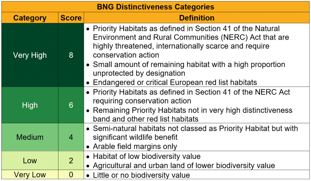
For Greater London, GiGL’s comprehensive Habitat and Land Use (HLU) dataset is the key resource for identifying the current ecological networks spanning the city and finding opportunities to improve habitat size, quality and connectivity. Therefore, GiGL’s ENM methodology uses the HLU data combined with the BNG distinctiveness scoring system (outlined below) to display the ecological value of different habitats, thus highlighting London’s ecological network.
When designing the methodology, GiGL worked with a number of stakeholders via a focus group. This process was useful for identifying the following key considerations for ENM:
- The outputs should be publishable and easy for the general public to understand
- Outer London boroughs will require data from other counties for a complete ENM
- The methodology needs to work for both urban and rural areas
- There will inevitably be different networks for different types of ecology
- The networks found will only be as accurate as the data ara
The focus group was particularly interested in a map produced using a GIS tool called Linkage Mapper. This tool was first used by GiGL when constructing London’s East-West B-Line that linked pollinator friendly habitats in London. It identifies the pathways of “least resistance” between specified areas and can be adapted to include different inputs. We have run two models to ultimately define two different networks, these are:
- Modelling pathways of high value habitat between protected sites i.e. the tool finds the most likely ecological networks between sites known for their ecological significance. Thus inferring where habitat improvement could be focussed. See map on the left below.
- Modelling pathways of low value habitat between core high value habitats i.e. the tool identifies areas of opportunity for building better connected networks between habitats with a distinctiveness score of 8. See map on the right below.


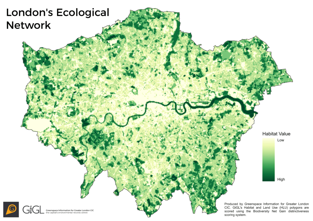
Linkage Mapper is a useful tool at a borough scale, however its capabilities are limited when it comes to an area as big as Greater London. Therefore, alongside the linkage maps we have also designed a hexagon-based ENM that gives each grid cell a score based on the distinctiveness scores of each polygon within that cell (example below). This highlights the areas of greatest habitat value, therefore displaying the ecological network.
Both the linkage map and hexagon grid map are available on request to partners with a Service Level Agreement (SLA). The latter map can be published externally if partners wish to do so. For partners with a London-wide SLA, we can create linkage maps for specific, smaller, areas if needed. The linkage maps displayed in this article are to demonstrate what the tool can do, and will be the default service offered to our partners. However we are open to trialling the tool with different inputs to produce different networks, so please get in touch if you are interested in exploring this further.
Looking Forward
Improving data: The accuracy of ENM is reliant on the underlying habitat data being correct. We are constantly developing and updating our HLU dataset and have a few pilot projects with partners working on specific areas to check its accuracy with ground truthing. It is therefore our aim to update the network maps on an annual basis to account for any improvements to the data over that year. Data improvements will also include developing agreements with surrounding counties to provide outer London boroughs with a buffer of data surrounding their borough boundary.
Improving resolution: The methodology does not currently consider patches of vegetation that fall in “urban” areas and it assigns the same score to gardens, regardless of their “greenness”. These omissions do not majorly impact the broad results of ENM but could alter any decisions made from the map if looking at a local scale. We are looking to improve our methodology with LiDAR data, which uses light to measure distances and create 3D maps of surfaces. This will allow identification of vegetation, no matter its location, and in turn, higher scores can be assigned to those areas where vegetation is present. LiDAR data will also aid mapping of 3D resistance i.e. taking building height and elevation into consideration when constructing the ecological network.
Expanding networks: As was discussed during the ENM focus group, different ecosystems will likely have different ecological networks. As a starting point, we have used all our habitat data to define broad ecological networks, however this can be easily tailored to identify connections between specific habitats e.g. woodlands or grasslands.
Summary
Uncovering Greater London’s ecological networks will play a vital role in influencing land management and habitat expansion decisions, focusing local recording effort and directing community participation. We hope that our maps will be useful not only for identifying current networks, but also highlighting opportunities for creating new ones. In the long run, this will help to improve the connectivity of nature in Greater London whilst also having a positive impact on people’s access to nature by reducing Areas of Deficiency. We will continue to develop our methodology with new data and techniques and welcome any feedback from our partners on how they plan to use the outputs or if they have any suggestions for improvements.
Sounds interesting and useful. I, for one, would like to see maps for my borough (Ealing). But if it requires usiing complex sotfware, forget it!