GiGL is proud to have worked alongside the Greater London Authority (GLA) to help produce our city’s first Local Nature Recovery Strategy (LNRS). We’ve played a central role in ensuring the strategy, which provides a spatial plan for helping nature flourish across the capital, is based on robust evidence alongside community insight and professional expertise. With the LNRS having been formally published this month, we’re taking the opportunity to celebrate GiGL’s part in the project.
Local Action for Nature
A requirement of the Environment Act 2021, there will soon be 48 Local Nature Recovery Strategies covering all of England. They aim to guide local action for nature recovery, mapping key habitats and agreeing local priorities, and areas for their delivery. They will be an important mechanism for directing funding too – including that from Biodiversity Net Gain. Each Strategy consists of a written statement of biodiversity priorities and a local habitat map. The Statement details the habitat priorities for each area, along with “potential measures” to achieve those priorities, and also species that are a priority for recovery.
GiGL as Expert Advisor
In June 2023, Defra appointed the Mayor of London as the responsible authority for producing the London LNRS. It was at this time that the GLA asked GiGL for assistance, and provided funding for us to employ two new staff, Emily and Clara, increasing our capacity to deliver some key LNRS-specific work. GiGL has led the creation of the three GIS datasets displayed on the Local Habitat Map, used our network of experts to co-ordinate the determination of what species should be the focus of the strategy, and created tools to facilitate stakeholder engagement.
Quote from Sarah Smith, Senior Policy and Programme Officer, Environment Team, Greater London Authority:
“GiGL was crucial to development of London’s LNRS – it was a real team effort, with many GiGLers involved in mapping, spatial data, and species-focused work.
While development of the LNRS was not without its challenges, the GiGL team worked hard to help us overcome them.”
Providing Verified Core Data
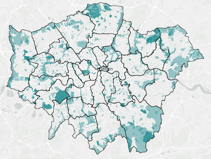
A key element of LNRSs is understanding areas that are already important for Biodiversity. These “Areas of Particular Importance for Biodiversity” (APIB) comprise statutorily designated nature conservation sites, local wildlife sites (in London called Sites of Importance for Nature Conservation – SINCs) and irreplaceable habitats.
GiGL is custodian of London’s dataset of SINCs. We liaised with our Local Authority contacts to ensure these data were up to date, ensuring the data reflected areas designated in Local Plans as well as incorporating some proposed sites soon to be designated.
Ancient Woodland is an irreplaceable habitat. It was great that the creation of the LNRS coincided with the publication of the updated Ancient Woodland Inventory dataset for Greater London, on which we worked on behalf of The Woodland Trust and Natural England.
Datasets included in the APIB layer:
- Special Areas of Conservation
- Special Protection Areas
- Ramsar Sites
- Sites of Special Scientific Interest
- National Nature Reserves
- Local Nature Reserves
- SINCs
- proposed SINCs
- Ancient Woodland Inventory
- Ancient Tree Inventory
Harnessing Local Expertise
Another way we supported the GLA was in the creation of LNRS species priorities. The process involved two stages: firstly, identifying threatened and other locally significant species. In London we already had a long list of 1,467 species, which were initially identified in the early stages of creating 2019’s update of London’s Priority Species List (more information available here). The second stage determined which of these species should be prioritised for recovery action. We asked our network of taxon specialists to create shortlists for each taxon based on:
- sense checking the 2019 lists to ensure they are still relevant
- identifying species LNRS can best support via defined action categories
- grouping species into habitat-based assemblages
- considering additional considerations such as urgency, feasibility, national species recovery, joining-up opportunities, maximising benefits, climate change impacts, pre-existing species initiatives.
The LNRS list of focus species is a combination of individual species and species assemblages. Potential measures for each species priority were also identified and defined.
The list of LNRS focus species is available here, and the longlist on the GiGL website.


Empowering Londoners to Shape the Strategy
Unlike some other LNRS, the London Strategy is stakeholder led. This means the areas identified as locations for potential measures for nature recovery were suggested by those with local knowledge, from conservation professionals, landowners and managers to community groups and residents.
We created an online mapping tool to ensure that everyone’s voices could be heard. Participants were able to plot their suggestions directly onto the map, while an accompanying online survey captured details about each proposed nature‑recovery opportunity.
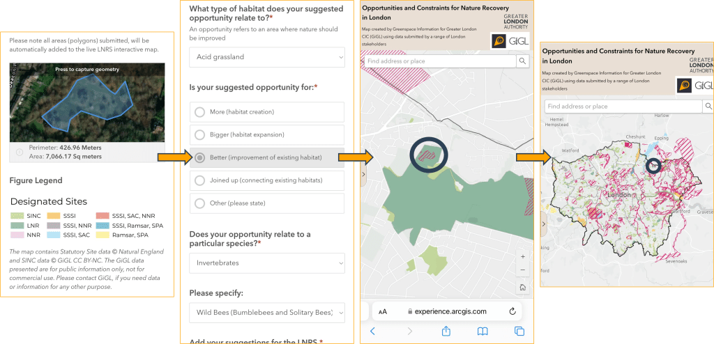
GiGL validated the results of the online survey, ensuring these Potential Measure Locations had the necessary information, but also checking their spatial extent was sensible, and re-mapping to a better degree of accuracy where needed using GiGL’s existing evidence-base and Ordnance Survey MasterMap base-mapping.
Evidence-based decision making
We wanted to ensure that the potential measure locations suggested by stakeholders were suitable and appropriate.
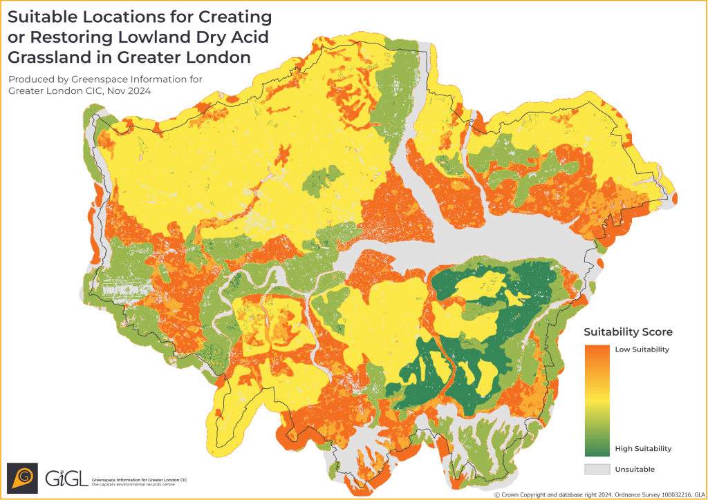
Our habitat suitability modelling maps areas of London suitable for the creation or restoration of different priority habitats. It considers things like the soil type or hydrology needed by each habitat, as well as the presence of indicator species. By comparing the potential measure locations for each priority habitat with the matching habitat suitability modelling we could ensure suggestions were viable.
To ensure that no inappropriate alterations were proposed to existing priority habitat, we also collaborated with our network of Local Authority ecologists to review and address any potential conflicts. We were also able to use our expertise of other available external datasets, to ensure the Strategy was grounded on as much evidence as possible.
Details on GiGL’s methodology are available in the LNRS method statement.
The evidence base behind the LNRS is available from GiGL. It is continually maintained as it is important that updated information is used to inform decision making.
Presenting the Local Habitat Map
The Local Habitat Map pulls together the three spatial LNRS layers; the APIBs, the Potential Measure Locations, and finally Areas that Could Become important for biodiversity (ACBs), which are ideas identified as potential measure locations where they fall outside of existing APIBs. We’ve used our mapping expertise to create a clear and usable Local Habitat Map, which carefully details what each of the layers represents and what to bear in mind when using the information.
What’s next?
LNRSs will be renewed every 3-10 years. Accurate monitoring will be necessary for the Strategy, and subsequent versions, to be successful.
If data and information are shared with us in the right formats, we will be able to effectively track changes since the last publication of the LNRS. By drawing on these data, we can inspire action, strengthen our decisions, and drive meaningful change.
How to get involved
Explore GiGL’s new StoryMap webpage, designed to guide partners and community members in using GiGL data and services to apply the LNRS.
Discover the steps you can take – from small but vital actions, such as recording species in your local area, to larger efforts, such as advocating for the use of data in development and planning.
If you have a project idea or would like to discuss how GiGL can help you protect and enhance what matters most in your area, please get in touch.