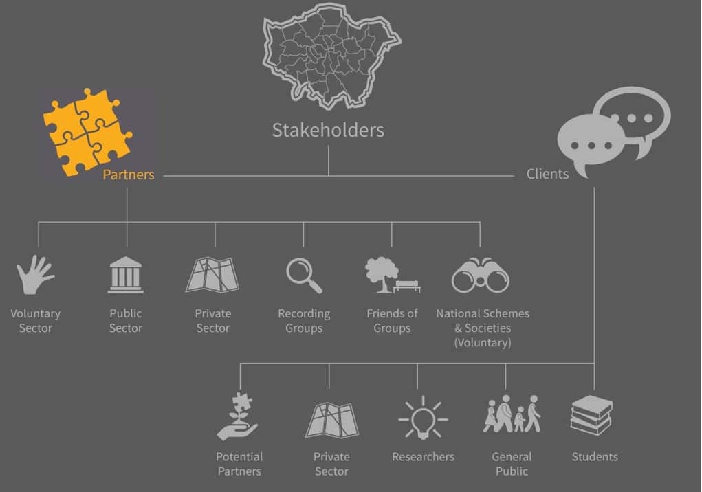
Partnership is used to describe relationships, business
associations and cultural collaborations. Partnership is about sharing and
shared endeavours. To GiGL, our partners are organisations who have a stake in
London’s natural environment and the data that illuminate it and this is why
they access our services or work with us.
GiGL’s broad range of partners includes organisations who have an ongoing need to access services and resources that GiGL offer and for whom a formal Service Level Agreement (SLA) contract and data use licence provides solutions.
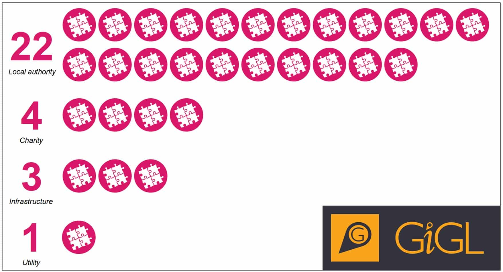
Who are our SLA partners?
Our SLA partners (correct as of May 2019)
Our SLA partners are major land managers, policy makers and decision takers in London. They have remits and responsibilities that include taking account of the natural environment in their work. An SLA and data use licence provides flexible options for partners to get the answers they need from GiGL’s evidence base.
What ongoing needs can SLAs support?
The need to responsively inform action
Partners with land management responsibility often have staff and contractors working on operations that may affect biodiversity or open spaces. They have legal responsibilities and organisational aspirations to fulfil.
Local authority partners also have a duty to consider nature related information when responding to planning applications. Planners and biodiversity officers (if present) within a borough need to understand which applications are likely to be sensitive regarding nature or open space provision and to provide responses informed by available evidence.
SLAs provide flexible access to data
The GiGL SLA enables partners to incorporate useful data directly into their company web mapping systems, so technical officers and licensed consultants can refer to evidence at the click of a mouse. Alternatively, on a case by case basis staff can ask GiGL for a report or other output summarising local features based on the evidence base.
These services enable users to see what others have seen at their site of operations or planning application – for example wildlife observations, or recorded habitats and features. The information also highlights any designations, known access and modelled access deficiencies. This evidence supports operational staff’s actions and planning decision making. Are there known risks to wildlife or green infrastructure to take into account? Are there clues to opportunities that could be seized?
The need to evaluate and plan
Sometimes partners need to explore the data at a high level, to support large-scale decisions and comparisons or to communicate at the right scale with their stakeholders, customers or the public. For example, policy makers need to evaluate and communicate resources and decisions within policy documents and action plans.
SLAs provide analysis and visualisations
SLA partners can commission GiGL to analyse and produce custom outputs such as maps, charts or statistics and arrange appropriate publication permissions.
The data use licence also unlocks potential for in-house analysis by a partner (or their licensed contractors, by arrangement) of the curated Geographical Information System (GIS) records.
SLAs provide sign-posting and advice
SLAs come with access to people as well as data. GiGL’s team are on hand to partners when they need to ask questions about the data, their history or what can be done with them. Our approachable team are available to discuss and develop delivery of data products or services and can often sign-post other partners, contacts or past projects to support SLA partners’ initiatives.
The need to recognise local value
SLA partners use data but also generate it. Land managers and contractors, in particular, generate much data of value regarding their resources – this includes wildlife observations, features and facilities of open spaces, wildlife habitats and (in the case of local authorities) land designations.
Planning applicants’ environmental consultants expect to see accurate local data available in a one-stop service to inform their expert advice to clients. Members of the public appreciate up-to-date information about their local spaces and wildlife.
SLAs provide data curation and sharing
Achieving a collated evidence base, fit for multiple uses, requires careful application of data standards, storage and metadata. For land cover and wildlife records, GiGL are able to do this on our SLA partners’ behalf, incorporating their newer data into existing London-wide baseline databases that are available for them and other partners to consult now and in future.
Engaging with GiGL and exchanging data means standardisation, storage and sharing via services of locally generated data. Crucially, these combined data inform best practice decision making within the planning system by being available to ecological consultants, planners and those engaging with the planning process via GiGL’s different services.
GiGL can also offer an impartial custodianship of Biodiversity Net Gain data, ensuring that the ‘before’, monitoring of, and ‘after’ development survey data are comparable and reported on.
Becoming a GiGL SLA partner
Find out more by visiting our website or meeting us for a chat. We can go into more detail about the services you would access via an SLA and how we could tailor these services to your requirements.
1 Comment
Rodger
on 31 May 2019 at 4:20 pm
Well done Chloe , article really helped me to understand exactly how your partnerships work


Well done Chloe , article really helped me to understand exactly how your partnerships work