Benjamin Town, GiGL Community Officer
Ben is GiGL’s Community Officer. He delivers work for community partners and clients. This includes work for members of the public and community groups, as well as carrying out work with students that wish to use GiGL data for research projects. At times he focuses on internal database work and core projects.
Environmental data have always been one of the cornerstones of planning applications and with the increased importance and influence that the living environment has on our city, the drive for a well-informed planning process has only increased. Guidelines set out by the NPPF (National Planning Policy Framework) and CIEEM (Charted institute of Ecology and Environmental Management) have highlighted how Sites of Importance for Nature Conservation (SINCs) and other priority areas need to be considered in all planning applications.
The NPPF further advises all planning applications to contribute to the achievement of sustainable development, to engage planners and communities, to be publicly accessible, and to serve a clear purpose; overall moving in a direction to create a more inclusive and informed planning process. As the NPPF recognises, there is a clear demand for a more transparent and unambiguous method of communicating environmental data, especially to the wider public. Therefore at GiGL, we have produced a series of borough planning sheets, simply known as factsheets.
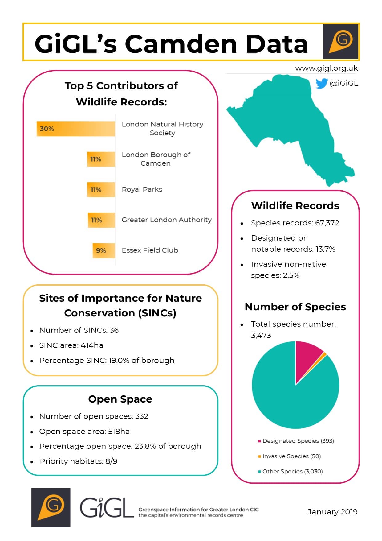
The borough factsheets are visualisations of data that enable us to easily communicate important information to a public audience. By distilling all environmental data to a single, easily digestible sheet, the communities affected by planning can be as well informed as the planners themselves. Our factsheets provide information on species numbers, open spaces and SINCs, giving an overview of the environment in each individual borough. Spotlighting the top contributors of wildlife records for a borough shows who the key environmental stakeholders are; it may act as encouragement for organisations to continue their recording effort and increases exposure of their activity within the borough.
Creating a visual way of representing a borough’s natural environment and increasing accessibility to this information has allowed our factsheets to reach a wider audience. Organisations such as ‘Friends of’ groups – groups who have an interest in a local greenspace and act for the improvement, conservation, and promotion of such spaces – have expressed an interest in these factsheets for their areas of interest. It is for this reason as part of our commitment to the community as a social enterprise, we have started to produce tailored factsheets for Friends of and other community group areas upon request.
Tools like the factsheets, whether they be for boroughs or for much smaller groups, facilitate a sharing of information in a quick and concise way and can contribute to building that better-informed planning society outlined in the NPPF guidelines.
One of the ways we are communicating these fact sheets to a wider public audience, is on our #GiGLBoroughCoutdown borough guessing game. Every Wednesday at 9am a new borough outline is released and our followers then have up until 5pm to guess which borough it is, upon which the corresponding factsheet is released; it’s a lot harder than it seems!
If you want to join in, you can follow our Twitter account, or like our Facebook page.
Are these borough level summaries available to the general public? It would be very useful to take the one for LB Richmond for example and share it with the Richmond BAP group as well as via Facebook with local data recorders etc
Hi Rob,
Yes they are; we created these factsheets to essentially act as talking points and initiate conversations about the natural environment in London. Sharing them with local organisations, at BAP meetings and on various social media platforms are great examples of how we envisaged them to be used so thank you for showing an interest! We will update the webpage to make clear of any relevant licencing policies involved with the factsheets and facilitate direct downloads in the near future.
In the meantime, please get in touch with me or Ben if you would like to receive a PDF copy of the factsheets you are interested in and we can forward them to you.