Laura Kuurne (GiGL Database Officer) and Chloë Smith (GiGL Partnership Manager)
This summer has been an exciting time for GiGL as we have been working on a brand new habitat database. Our legacy habitat datasets (we’ve never had a habitat database) have served us, our partners and our stakeholders incredibly well but the diversity and coverage of having this new database will provide greater opportunities to better monitor, understand and improve the habitat landscape. It has the potential to revolutionise the ways in which we can study the natural environment in London and we are confident this database will better support both The Mayor’s London Environment Strategy and the delivery of Biodiversity Net Gain. Brace yourselves – here’s everything you need to know about this exciting new project.
The new GiGL habitat database translates and stores the legacy of information from London’s rolling borough-by-borough habitat survey (1984-2008), subsequent local surveys since, and Ordnance Survey’s (OS) land use data. All of this information is aggregated into the Integrated Habitat System (IHS) within an OS MasterMap-based framework, and includes additional information about topology and classification. What makes this hierarchical system special is that it allows us to incorporate data from all standard survey methods. This enables GiGL to export habitat information as simple IHS codes, broad habitat types, or priority habitats for your area of interest. We can also translate the data back into other metrics useful for different users and audiences. For example, the data can easily be translated to UK Habitat Classifications, making it particularly useful for work relating to Biodiversity Net Gain.
At GiGL, we are constantly developing our core datasets and making sure they match the current needs for our partners and stakeholders. As well as finding new ways to use and develop existing data, we recognise the importance of being flexible and incorporating additional sources. We feel that now, more than ever, is a great time to develop a comprehensive habitat database, as it will allow us to provide services relating to the design, implementation and ongoing monitoring of work relating to Biodiversity Net Gain. The database will also “establish a cost-effective monitoring framework, to ensure important natural environment data is collected consistently”, as proposed by The Mayor in the London Environmental Strategy (p.189).
As well as studying the array of habitats in an area, the database can be used to compliment and be complimented by our other spatial databases and our species database; our open space data can provide further information about a habitat’s land use, ownership, accessibility and designations; our species data can help inform the biodiversity of a habitat. The habitat database can also be used to accompany data from external sources such as the GLA’s London Green and Blue Cover; while GLA’s dataset is good for quantitative analysis of vegetation cover, our new habitat database can be used for qualitative analysis of the habitats involved. Together, they can provide opportunities to study urban greening and promote London’s natural capital and green infrastructure.
The data from this database will be available under the same terms as our other core datasets. The actual GIS data will be available only for our Service Level Agreement (SLA) partners but the information will be displayed as part of our data search reports. The data will also be available for anyone who is interested in conducting habitat-related studies in London, under the appropriate licence agreement of course.
The new habitat database is currently a beta version only. We have been using the database for a few projects so far to better understand and learn its practical limitations and capabilities. For example, it is currently being used for a case study located within a development corporation region, to calculate precise areas of its different habitat and land-use types. Although the project is still on-going, we have already learnt a lot about how best to use the database to meet different demands. There is no release date for the habitat database just yet, but we are currently looking for opportunities to conduct more case studies like this and deepen our understanding of its best practice.
Getting the most out of habitat data: London Borough of Sutton
Habitat data can be used in a variety of ways, you just need to know how. One SLA partner, the
London Borough of Sutton, have been working closely with us to best utilise the
data we hold for the borough.
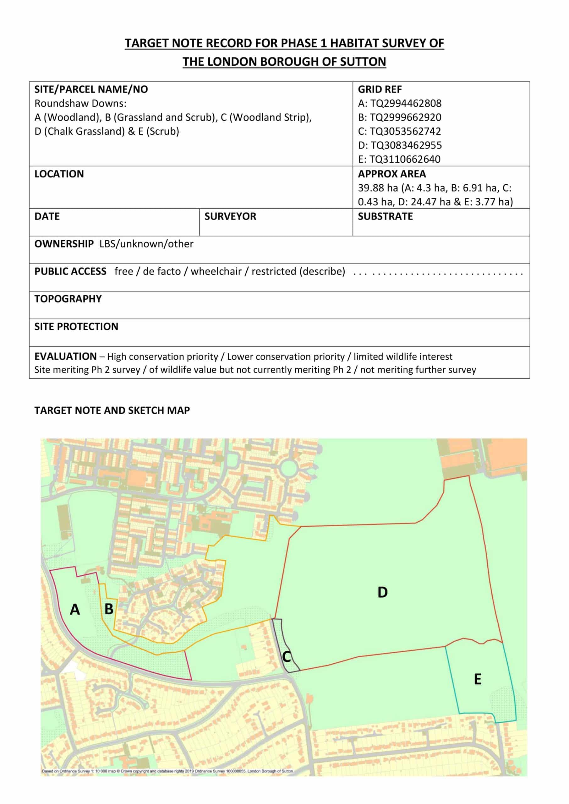
Phase 1 Habitat survey sheet: Roundshaw Downs
LB Sutton closely and consistently monitor their sites through an annual habitat survey and a number of condition assessment surveys. The data they collect during these surveys
help update GiGL’s borough habitat data (from 2006) and refine the information we hold for the surveyed habitat parcels. To help with the process this year, GiGL created a series of Phase 1 habitat survey sheets for each survey site including mapped habitat boundaries (using our legacy dataset), habitat composition information, and a list of any designated species recorded on the land.
GiGL Officers Laura and Min had the grateful opportunity this summer to shadow Sutton’s Senior Biodiversity Officer David Warburton on one of these annual surveys at Roundshaw Downs. It was a rare outing for the desk jockeys but one that definitely helped GiGL better understand the realities of recording habitat data on-site.
LB Sutton’s use of the habitat data doesn’t stop there. The data collected during the annual surveys are being used to start the process of understanding their sites in terms of Biodiversity Net Gain. We are hoping that this will ‘ground truth’ the work GiGL Partnership Manager Chloë has done scoring habitats based on the legacy dataset. If we can analyse how closely Net Gain relates to our scoring system, we can theoretically score habitats across all of London using our legacy dataset without having to remap or resurvey each site. These scores can then provide heatmaps of habitat opportunity areas for further study.
We hope we can engage in more projects involving our habitat data and be able to use our new database for projects like this in the near future.
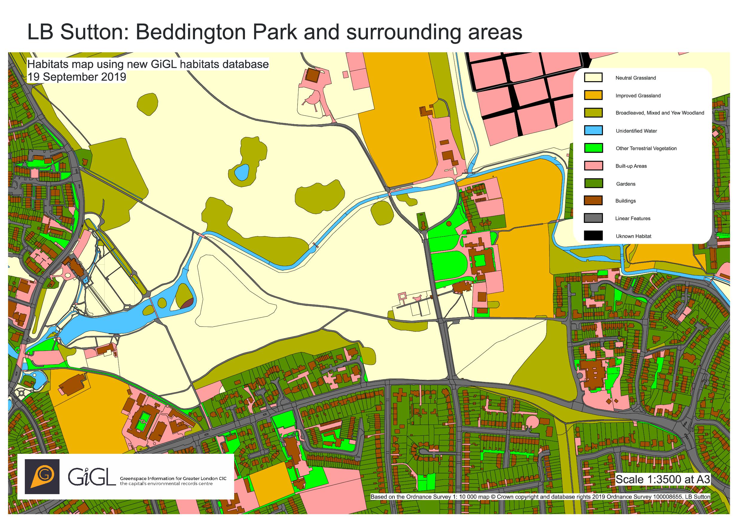
Preview of the new habitats database
2 Comments
Mol
on 24 October 2019 at 1:42 pm
it all helps
David Malcolm Castle
on 2 January 2020 at 11:22 am
Very worthwhile
Anything on Hampstead yet?
The Heath & Hampstead Society
it all helps
Very worthwhile
Anything on Hampstead yet?
The Heath & Hampstead Society