
Access to open space matters. It improves mental and physical health, strengthens communities and helps improve climate change resilience. If you’re lucky enough to be able to step outside your front door and head down to a local park, river walk or nature reserve, then I’m sure you’ve experienced the positive impact that can have on your day.
But access is the key and these benefits are not equally spread, especially so in large and complex cities like London. Distance, lack of transport and physical barriers all impact how easily people can get to different types of open space.
Whether to support public health or inform planning policy, understanding where access is lacking is a crucial first step. Identifying those areas allows planners, policymakers and communities to target investment and interventions to start to reduce those inequalities.
As interest in this area grows nationally, a range of different approaches to assessing access have emerged. At GiGL, we’ve been modelling Areas of Deficiency (AoD) since 2009 with the goal of supporting evidence-based decision making. In this article we’ll compare a national and local approach and explore the value of these datasets.
Measuring accessibility
At its core, accessibility modelling is pretty straightforward. You need to identify who can reach a particular type of space within a defined distance, and who can’t.
Some models use simple straight-line measurements, or ‘as the crow flies’, which assumes people can travel directly from point A to B without facing any barriers. Others can be far more sophisticated, incorporating walking networks, site entrances, public transport, physical barriers, population distribution and many other factors to build a realistic picture of how people move.
Different methodologies have been created to answer different questions while balancing factors like consistency, accuracy and data availability.
Natural England’s Accessible Greenspace Standard
Natural England’s Accessible Greenspace Standard (AGS) forms part of the Green Infrastructure Framework and provides a nationally consistent approach for assessing access to natural greenspace.
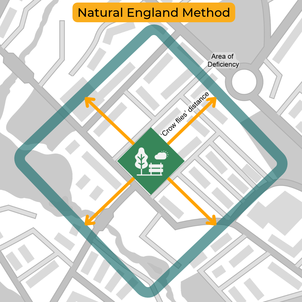
The method incorporates national datasets with standardised size, proximity, capacity and quality criteria, considering a range of publicly accessible natural greenspaces. This maps whether people can access these green and blue spaces of within recommended travel ‘crow flies’ distances.
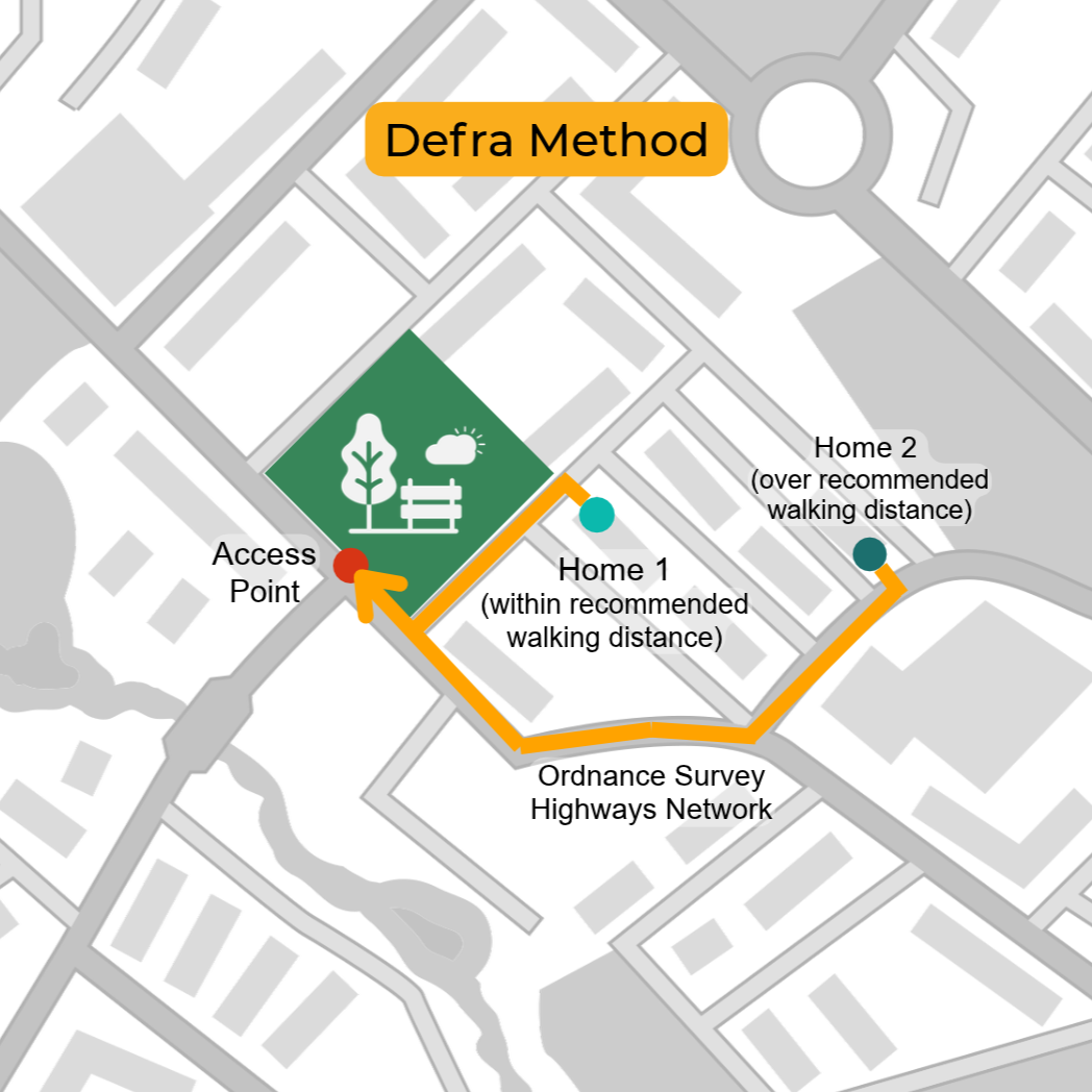
Defra have built on this to develop an England wide ‘Access to Green Space in England’ Official Statistic in development, which uses network analysis and actual walking routes to greenspace proximity for Doorstep, Local and Neighbourhood Accessible Greenspace Standard criteria. This finds the shortest distance from households to qualifying site access points to understand which are outside of the distance criteria.
These methodologies are applied across England, whether in rural or urban areas, providing a standardised evidence base. This national approach helps to understand patterns and identify areas where provision is lacking, which can then be used for national policy, strategic planning and monitoring.
National-scale models do, however, face unavoidable limitations. They rely on datasets that are available and consistent across the whole country and therefore cannot always reflect the nuances and data availability at a local level.
GiGL’s Areas of Deficiency (AoD) model
While Natural England’s methodology provides a national perspective, GiGL’s AoD model was developed specifically to support planning and decision-making in London.
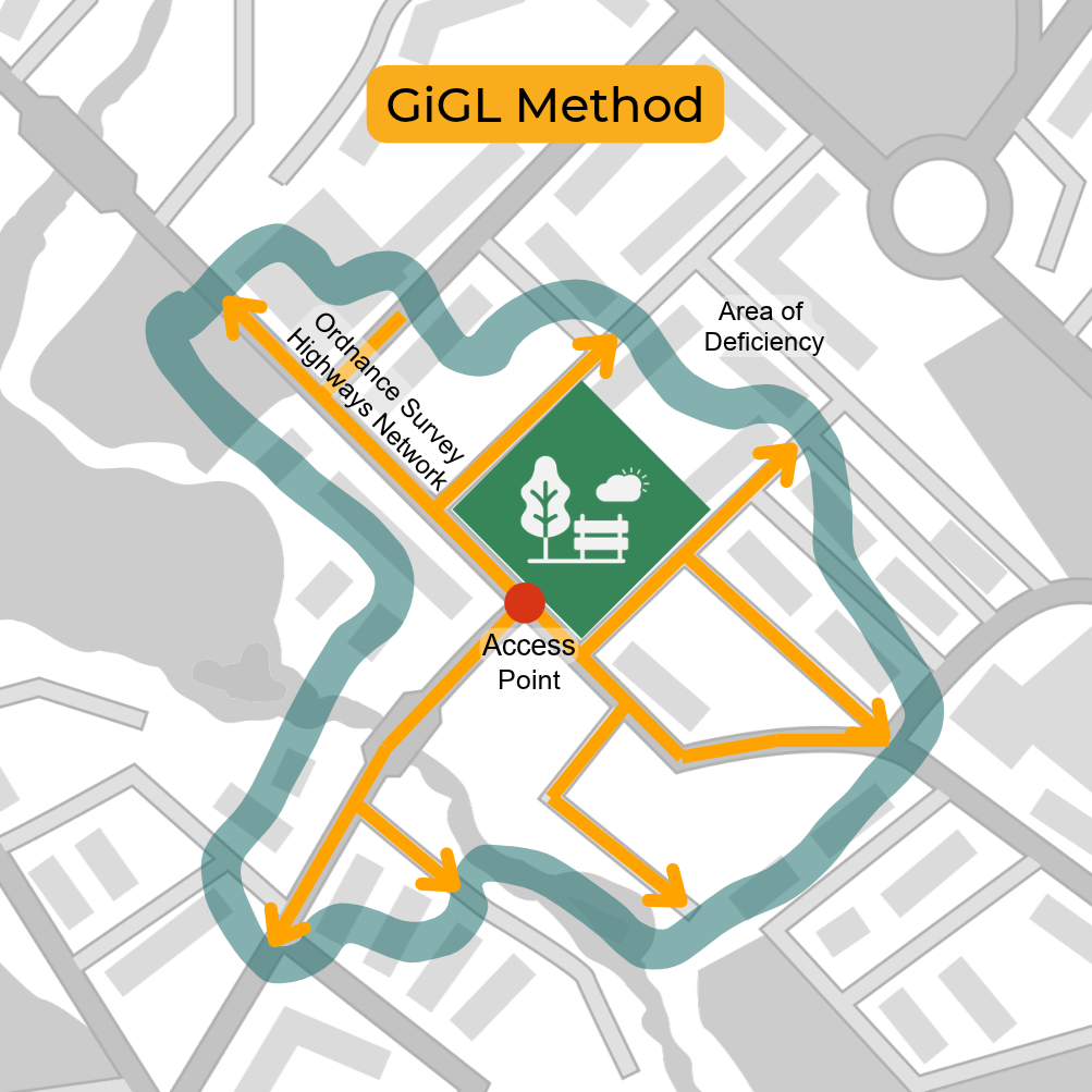
Areas of Deficiency are areas that fall outside defined walking distances from qualifying sites. This measures actual walking routes from entrances to sites, rather than straight-line distances, using road and path networks combined with verified site access points.
Over the years GiGL have developed two core AoD datasets:
- Areas of Deficiency in Access to Nature (SINC AoD): Areas more than 1 km walking distance from accessible borough-grade or above Sites of Importance for Nature Conservation (SINCs). SINCs are London’s Local Wildlife Sites and represent sites recognised for their importance to biodiversity.
- Areas of Deficiency in Access to Public Open Space (POS AoD): Areas outside of a maximum distance which London residents should have to travel to access a Public Open Space, as defined by the London Plan.
GiGL took on responsibility for managing SINC AoD in 2009, as part of the handover of the evidence base on SINCs by the Greater London Authority (GLA). The GLA Team had devised a means of mapping walking routes from SINCs that involved laying a length of string that represented 1km distance along roads and paths on hard copy maps. You can read more about the work the GLA Team did here in our 2012 Accessing Wildspace article.
GiGL have continued to work with our partners to develop these datasets further, including the London Wildlife Sites Board (LWSB) and the GLA, to tie in with planning policy like the London Plan. For more detail on the methodology and development of GiGL’s datasets, you can check out our previous GiGLer articles on Updating London’s Areas of Deficiency and Introducing GiGL’s new POSAoD maps.
Together, GiGL’s datasets provide a detailed evidence base that supports planning policy, green infrastructure strategies and projects across London.
Predictive modelling
One of the advantages of GiGL’s AoD model is that it is adaptable. It can be used to not only measure existing access, but also to model potential future scenarios, as well as focus in on particular site types or new walking distances.
Because the model was built around real access points, site boundaries and route networks, it can show how accessibility would change in these scenarios:
- New access points & route upgrades: Potential changes can be as simple as adding a new access point and have been proven to work in the past. For example, in Gillespie Park, Islington, a footbridge over a railway line was added as part of redevelopment plans in the area, which opened up the park to those living on the other side of the railway lines.
- Site changes & upgrades: We can also look at what would happen if sites are added, removed or modified. For instance, when sites are brought up to a standard where they start to reduce deficiency for specific factors, such as Access to Nature. This was done in Mountsfield Park and Bridgehouse Meadows which were upgraded from Local to Borough grade SINCs in Lewisham, drastically reducing AoD.
- Different walking distances: In his 2021 manifesto the Mayor pledged to ‘improve London’s network of green corridors and open spaces so that more Londoners live within a 10-minute walk of a green space’. We helped model just that to create the 10-minute walk map for the GLA. This applied a 800m walk to all accessible sites to represent how far someone walking at average speed can travel in 10 minutes.
- Site types & transport methods: Our model can also be tailored to assess access to any type of sites, such as play spaces or allotments. We have previously modelled walking distances to public open spaces from TfL stations and bus stops. This work provided evidence to support the development of a Green Infrastructure and Biodiversity Plan for TfL, identifying areas where transport access could be improved.
A whole range of scenarios can be tested using GiGL’s predictive modelling, with some examples of recent partnership work given below.
London Wildlife Trust New Towns
When the 2026 Draft London Plan proposed a series of new towns, London Wildlife Trust (LWT) wanted to understand what this would mean for AoD in Access to Nature.
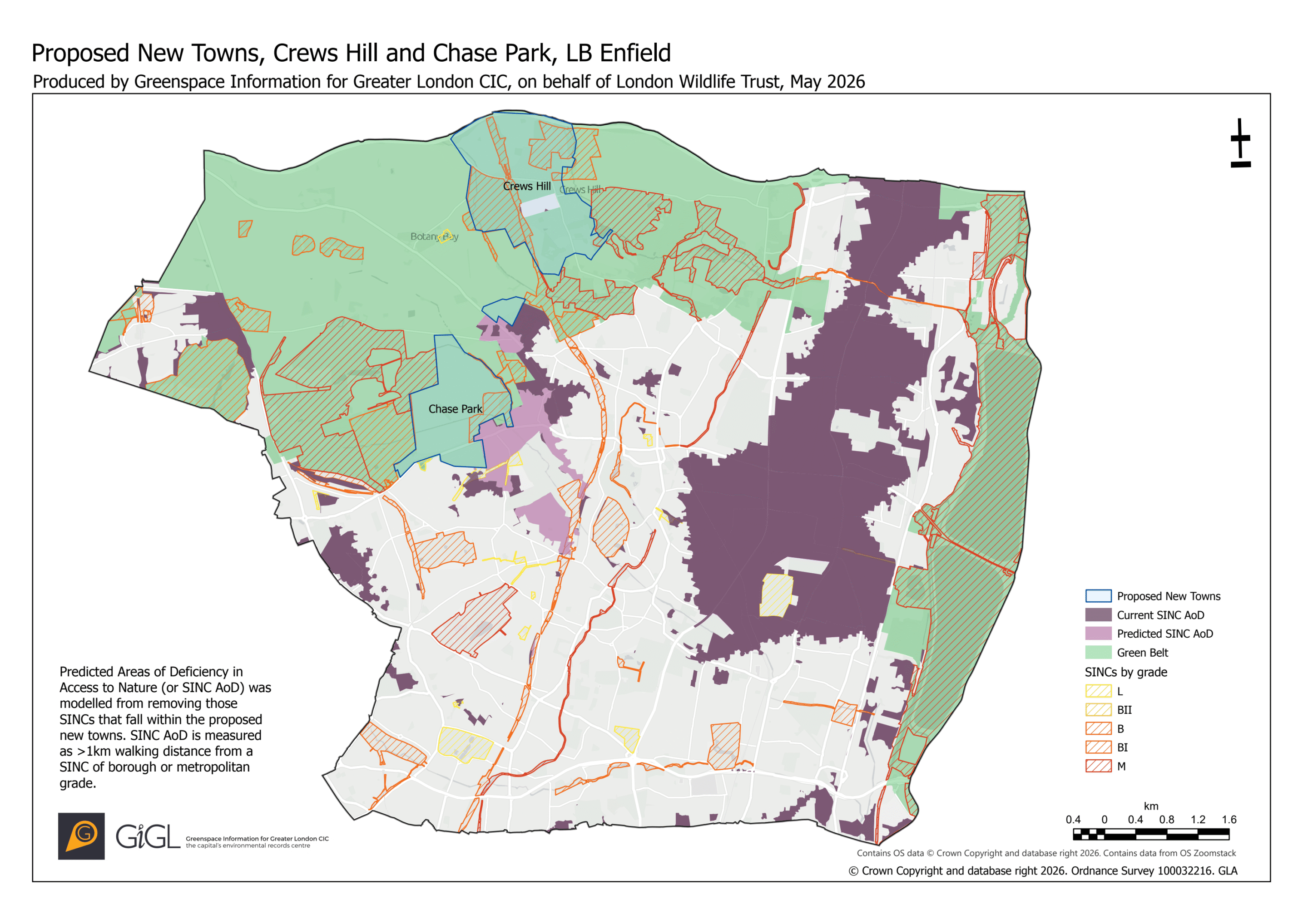
We mapped the approximate boundaries of the proposed new housing estates to identify areas of SINCs or Green Belt that would be lost, or were nearby. A predictive AoD model was then run to find out how these changes would impact access to nature, both for existing and new residents.
The model found that building in Crews Hill and Chase Park, Enfield, could increase borough-wide AoD by 2%, with Green Belt and SINC coverage both decreasing. Development around Chelsfield station in Bromley was shown to more than double AoD in Access to Nature in the local area, although there would be a relatively small impact across the borough as a whole. In both cases, the new developments would mean that more people would be living in areas that don’t have good access to high-quality natural spaces.
The modelling helped the Trust to understand the potential impact of the proposed new towns and provided evidence to support their response to the draft London Plan consultation.
Lewisham SINC AoD
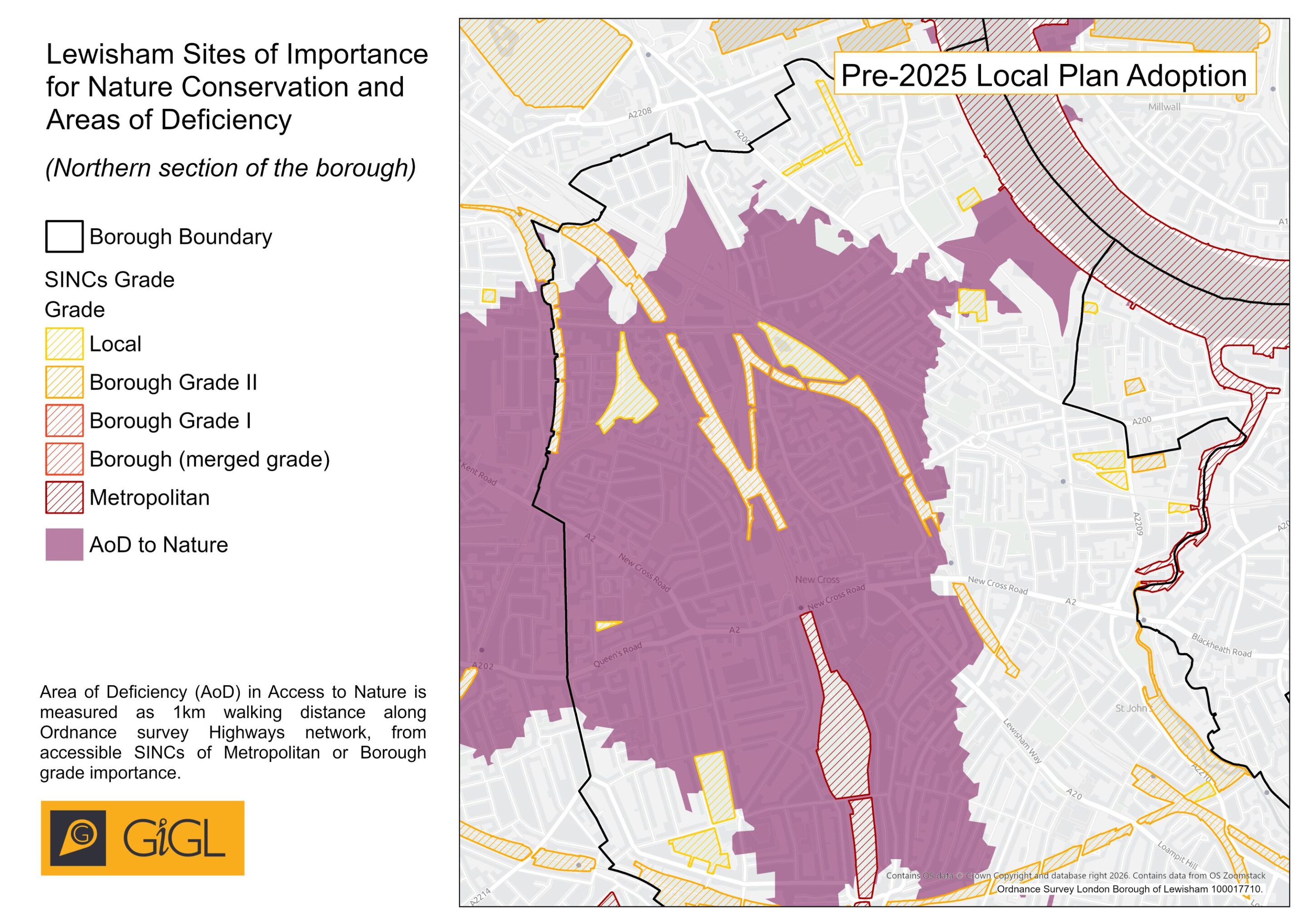
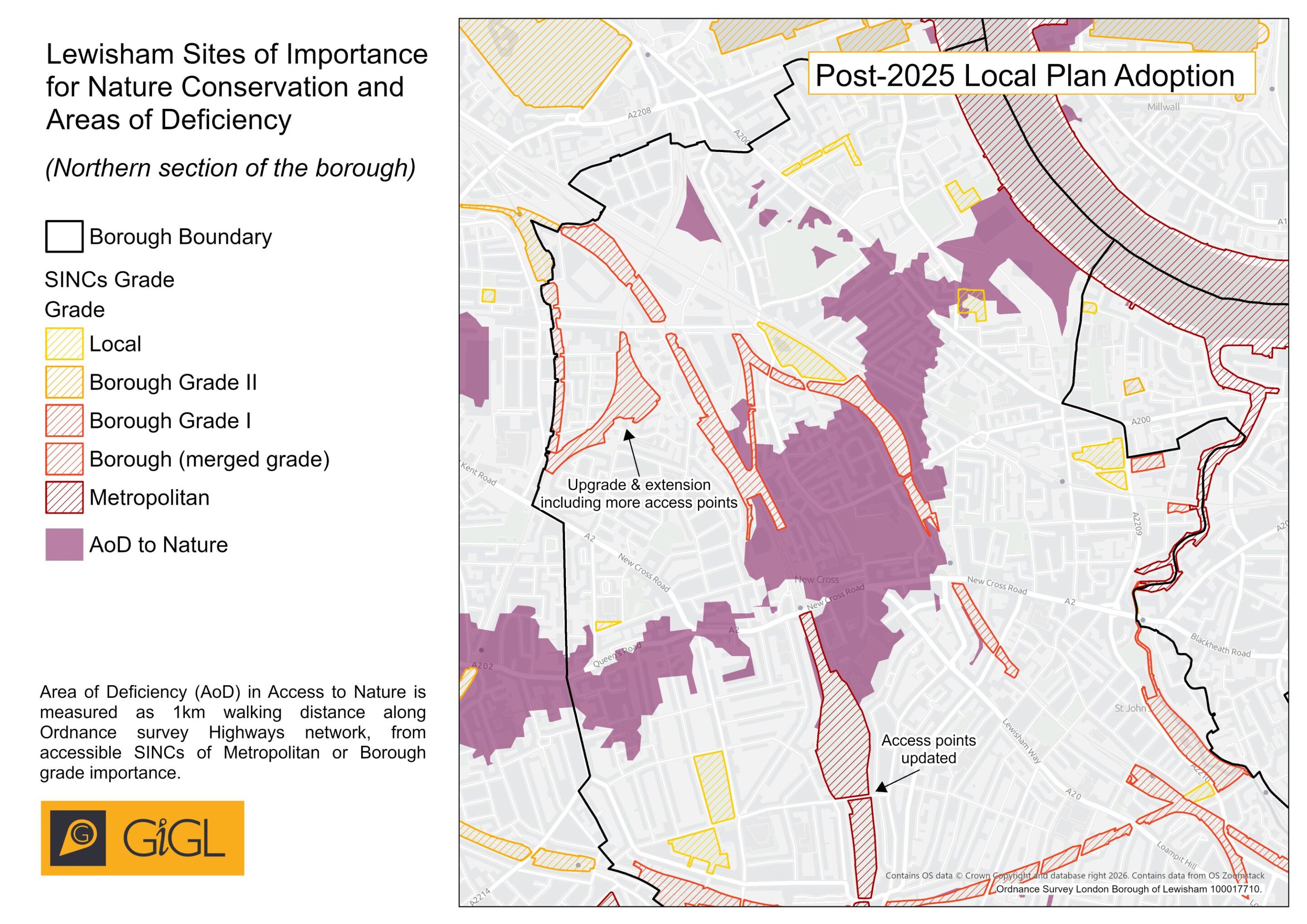
In Lewisham, GiGL’s predictive model was used to assess how the adoption of the borough’s Local Plan would affect AoD in Access to Nature. Prior to the Local Plan’s adoption, Lewisham had undertaken SINC reviews, resulting in several proposed SINC changes that were held within GiGL’s proposed SINC (pSINC) dataset.
Using this proposal data, GiGL modelled and compared AoD before and after the suggested SINC changes. Site upgrades, boundary extensions, and new access point information all contributed to improvements in access to nature. The modelling demonstrated a substantial reduction in AoD across the borough, highlighting the positive impact of the proposed changes. These results can be used to support borough reporting and demonstrate the value of protecting and enhancing sites of importance for nature conservation.
The future of accessibility modelling
Access modelling is evolving rapidly, and different models can help to answer different questions. Together they provide a richer understanding of how people access open spaces.
As our understanding of accessibility develops, so too do the models used to measure it. Although GiGL’s AoD datasets provide detailed maps tailored for London, they don’t yet capture every factor that influences whether people can comfortably access the outdoors.
Disabled access, path gradient and quality, lighting, and perceptions of safety can all affect people’s ability to access and enjoy sites, alongside many other factors. Access to private gardens and other forms of green infrastructure can also shape how we experience our local area. Nature and open space are also only two types of site. Access to play space, sports facilities, blue spaces and other open spaces are also important.
We also need to balance increasing accessibility with the need to protect some of our more vulnerable sites from overuse. In future this could involve assessing foot fall and AoD data together.
As new datasets become available and research continues to improve our understanding, there will be opportunities to develop increasingly sophisticated and nuanced models. GiGL are committed to continuing to work with our partners to ensure London’s accessibility evidence base remains robust, relevant and useful.
If you would like to know more about GiGL’s Areas of Deficiency datasets, discuss a bespoke accessibility project, or explore predictive modelling, please get in touch with amy.palmer-newton@gigl.org.uk.